Buying a GPS shouldn't be tricky; all you need is to get from point A to point B. Once you see everything else they can do, you'll be switching from your smartphone app over to a real GPS. Here are the best navigation systems whether you're a casual driver, and cross-country motorcyclists or a trucker with a long road ahead. No matter how far you plan to go, we recommend the TomTom GO COMFORT for most people because it is easy to use, lets you connect your cell phone via Bluetooth and includes with features to help you avoid traffic, weather delays and construction.
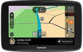
TomTom GO COMFORT
The one for all road trips
The GPS gives you directions but also connects to your phone for more hands-free options including voice control texts and calls.
Pros:
- Live traffic and weather updates
- Automatic map updates
- Connect your phone via Bluetooth
Cons:
- For cars only
- Only works in one language
The TomTom GO COMFORT is the best navigation system for the avid road-tripper with everything you need to know programmed into this single device. It will send you traffic updates and weather conditions, plus change your route to help find a quicker one if either of these interferes with your trip. It taps into current maps and will work for any trip within the continental U.S., Mexico, and Canada.
You can connect your phone to the TomTom GO COMFORT via Bluetooth. This lets you use voice controls to send texts, answer calls, or have incoming texts read out loud to you to avoid distracted driving. This only works in the language you purchase the device in. There is no way to switch languages after it is bought.
The touchscreen makes it easy to preset your trips and even share your journey details with others, like friends, so they can get up-to-date alerts of how close you are to meeting them. You can zoom in or out of the road map to see further ahead, or your current route. At a glance, you can see current speed limits and any gas stations up ahead. This navigation system is designed for cars and other personal vehicles. It can be used by motorcyclists, but there are other models more specifically designed for this. This isn’t a good choice for semi drivers.
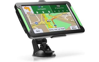
Lttrbx GPS Navigation for Car
Save a buck or two
This budget-friendly GPS system both shows and tells you directions anywhere in North America.
Pros:
- Free lifetime map updates
- Set reminders and warnings
- Touchscreen
- Positioning mount
Cons:
- North American maps only
- Very short warranty
Thus touchscreen GPS navigation system doesn’t cost too much but is still packed with the features and tools you need to get you to your destination. The Lttrbx system has 58 different languages and taps into over 101 regions within North America to get the most up-to-date maps. You can set this system to give you reminders about speed limit changes and places close by like grocery stores and gas stations, or receive warnings about speed traps and red lights ahead.
The 7-inch touchscreen shows you in real-time the roads you are on and how far until your next turn. And you can use voice directions, too, so you don’t always need to take your eyes off the road to view the map. If you do miss your turn, the Lttrbx GPS will automatically redirect you following the best route. It mounts onto the included bracket that suctions to your dashboard or windshield. The head of the mount moves so you can position the screen for easy viewing.
This GPS doesn’t come with as long of a warranty as other GPS navigation systems. But you do get a 30-day money-back guarantee and an additional couple of months to return a defective device for a replacement system. It’s still a good value for the price.

Best for Truckers - Rand McNally OverDryve 8 Pro
For truck-specific navigation
This voice-activated GPS helps truck drivers avoid bridges and toll routes with real-time navigation.
Pros:
- Truck-specific navigation
- Real-time updates
- Connects to electronic log systems
- SiriusXM radio
Cons:
- Expensive
- Mount isn't sturdy
I talked to a few semi drivers and fleet managers, and Rand McNally is their top pick for truck navigation. The Rand McNally OverDryve GPS navigation system gives you real-time updates for road conditions, including upcoming tolls, construction, and traffic jams. Rand McNally shows you the street layouts of your route, including road signs and traffic signals. It includes a dashcam to help digitally record drivers and road conditions around you and has SiriusXM radio built into its system.
Truckers can set this GPS system to warn of upcoming weight stations and speed limit changes. It helps you find truck-only routes, avoid toll roads and routes with bridges of a certain height. It shows truck stops and rest areas with enough time to decide when and where to stop before daily hours of service limits have been hit. The OverDryve connects with electronic log systems to help keep accurate reports and has so many voice-activated prompts including hands-free calls and texts, and news, weather and sports updates.
The biggest complaint truckers have with the Rand McNally OverDryve GPS is the mounting unit it comes with. It doesn’t adhere to the dashboard or window very well, and the magnet used to attach the GPS to the mount isn’t secured well causing the OverDryve to shift, rattle or fall off during use.
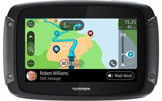
TomTom Rider 550
No cars allowed
This compact navigation system lets you customize road trips routes whether you want the quickest route or a more scenic one.
Pros:
- Road trip planning
- Weatherproof
- Built-in Wi-Fi
Cons:
- Requires app for trip planning
The TomTom Rider 550 is specifically designed for motorcycle trips. This weatherproof GPS will help you plan out trips in ways car and truck GPS systems can’t. You can preset your trip using the MyDrive app to find the more scenic paths, points of interest, and obscure lookout points. You can also connect your headset and use this navigation system to change the music you’re listening too, make calls, or hear text messages.
As with other TomTom GPS systems, this navigation device will alert you of traffic or weather changes with enough time to avoid traffic jams, construction, and other delays. It helps you find an alternative route or other important spots like gas stations, restaurants, rest stops, and hotels.
The included mount is designed to strap to your console in a way that it won’t easily come loose, twist, or fall off during your ride. Because it has a built-in Wi-Fi hotspot, you are subject to internet connection availability from nearby towers and satellite systems.
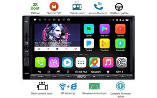
ATOTO A6 Navigation Stereo
All-in-one system
The ATOTO A6 stereo includes navigation to help you find points of interest or directions to your destination.
Pros:
- Lots of functions
- Permanently mounted
- Hands-free tools
Cons:
- Installation takes a while
- Only works with Android devices
This navigation system is incorporated into a car stereo system. This means you don’t have to mess with connecting and mounting a GPS device every time you get into the car. Instead, this stereo with built-in Wi-Fi will automatically come on and give you access to the latest maps, radio stations, and Bluetooth connected cell phones. The ATOTO A6 touch screen lets you easily toggle between each function without requiring you to take your eyes off the road for too long, or at all if you integrate the device to steering wheel controls.
The GPS function will both show and tell you directions based on the address you enter. You can see in advance when you need to turn and see warnings of traffic jams, red lights, speed limit changes, or changes in weather up ahead. The map will show you close by attractions and important points like gas stations and rest stops. Using its other hands-free tools, you can use this system to place and answer calls, or even send and receive text messages.
Because this is a stereo system, this GPS needs to be hardwired into your car. There is an instruction manual that comes with the ATOTO A6 and all the tools, wires, and connectors needed. If you’re not feeling confident about installing it yourself you will need to hire a professional to help. Also, Bluetooth connections only work with Android cell phones and tablets.
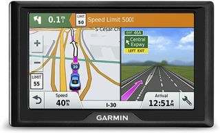
Garmin Drive 50
Keeping it simple
For straight routes for daily commutes or quick trips, the Garmin Drive 50 is the navigation system for you.
Pros:
- Inexpensive
- Foursquare compatibility
- Easy to use
Cons:
- No Bluetooth connectivity
- Low battery life
Sometimes you don’t need anything fancy, just a little help getting from here to there. While you can use your phone, the Garmin Drive 50 is the better option because it is more up-to-date with current traffic conditions, road closures, and weather delays. It connects to the Foursquare app to ensure all maps are accurate with a few points of interest in case you’d like a little diversion during your trip. For daily commutes, the Garmin lets you preset common routes.
The screen is easy to read with roads, speed limits, and traffic lights clearly designated. And you can see how far until your next turn so you’re not surprised at the last minute. There isn’t much more to this GPS navigation system than that. There isn’t a way to connect your phone for more hands-free driving. And the battery tends to wear out quickly, so you’ll need to recharge this device often.
Bottom line
Sometimes you need a bit more help than what your phone GPS gives you. Whether you want to save your phone’s battery while you’re on the road or stick with a dedicated system for extra features, there’s a navigation system out there for you. If you’re looking for the best one to take with you around the country, the TomTom GO COMFORT is the best. It offers all the perks including Bluetooth control and traffic updates, and maps throughout North America. You can save favorite routes and be alerted of any delays along with automatic route changes to avoid long waits. This is the perfect GPS for someone that likes to drive
For truckers, who depend heavily on navigation systems to help them stay on truck routes, avoid toll roads, and find truck stops, I recommend Rand McNally OverDryve 8 Pro. This system connects to electronic log systems to help keep track of driving and downtime. You see upcoming weigh stations, posted truck speeds limits and approaching road, weather, and traffic conditions.


